CarpAtlas · premium fishing intelligence
Fish smarter. Remember more. Spot patterns faster.
CarpAtlas is built for carp anglers who want to understand their waters better. Record waters, spots, sessions, catches, bait, rigs, weather and movements, then use map and analysis to see which choices produce more often. Free to try up to 2 waters, 4 sessions and 8 catches. Then a one-time purchase — no subscription.
Gratis proberen
2 wateren · 4 sessies · 8 vangsten · alle functionaliteit
Daarna eenmalig €12,99. Geen abonnement.
Waters & spots
Sessions & catches
Map & analysis
Gemaakt om gebruikt te worden
CarpAtlas verkoopt niet op hype, maar op herkenning.
Een karpervisser moet direct denken: dit bewaart precies de kennis die ik normaal in mijn hoofd, telefoon en losse notities kwijt raak.
Voor karpervissers
Geen generieke sport-app. CarpAtlas volgt hoe je echt vist: water leren kennen, stekken kiezen, sessies draaien en vangsten begrijpen.
Privacy verkoopt vertrouwen
Je stekken, notities en vangstlocaties zijn persoonlijk. CarpAtlas voelt als je eigen logboek, niet als een openbaar platform.
Inzicht in plaats van ruis
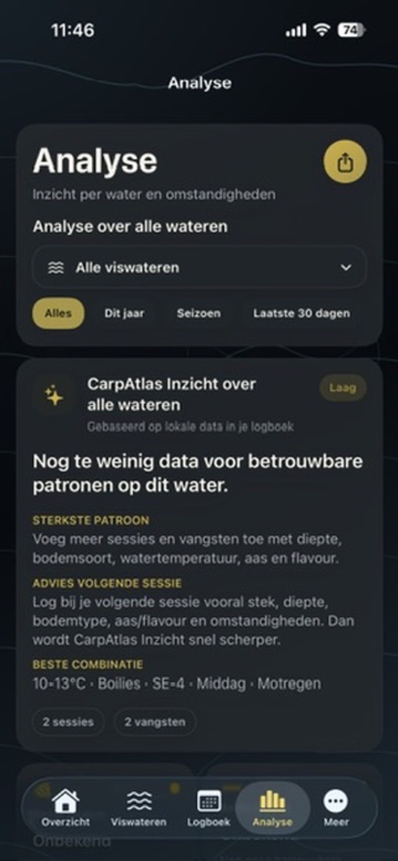
De app helpt je keuzes teruglezen: welke stekken, omstandigheden, aaskeuzes en tijdvensters vaker interessant zijn.
Duidelijke waarde vanaf dag één
Start met één water, voeg stekken toe, log je eerste sessie en zie meteen waarom alles op één plek hoort.
De kernbelofte: bouw je eigen waterkennis op, zonder abonnement en zonder je stekken te delen.
Download on the App Store →Wat CarpAtlas doet
Alles rond je water, sessies en vangsten in één rustig logboek.
CarpAtlas brengt de hele karperworkflow samen: van waterkaart en stekken tot vangstdata, weercontext, aas, rigs, diepte, bodemtype en lokale analyse.
Build your own water atlas
Save spots, zones, depth information, photos and notes per water. Everything you log later fits into place.
Log catches without noise
Record species, weight, rod, bait, rig, spot and time. Enough detail to make better decisions later.
Connect conditions to results
Save wind, temperature, pressure, humidity and other conditions with sessions and catches.
Discover what works more often
Compare waters, spots, timing, bait, depth and weather. Less guessing, more pattern recognition.
Import your own depth map
Use fishfinder or Deeper data as a bathymetric layer over your water map.
Fast input on the bank
Hints, required fields, autofill and filters keep your logbook clean without interrupting the session.
Volledige functionaliteit
Geen generiek dashboard, maar een logboek dat je visserij begrijpt.
Elke functie is gekozen omdat hij later helpt bij betere keuzes aan hetzelfde water. Je data blijft praktisch, lokaal en vergelijkbaar.
Viswateren
Maak per water een eigen profiel met foto’s, notities, zones, herkenningspunten en kaartcontext.
Stekken en zones
Leg visplekken, aasplekken, taluds, platen, wierbedden, harde bodem en zachte bodem vast.
Sessies, trips en verplaatsingen
Koppel datum, tijd, hengels, aasplekken, stekwissels en meerdaagse trips aan het juiste water.
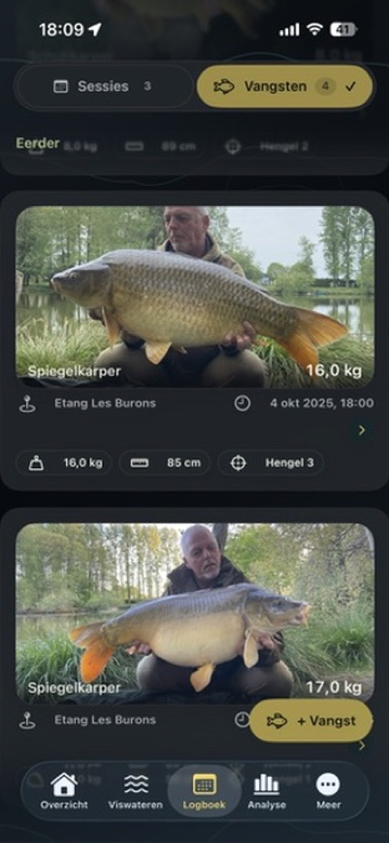
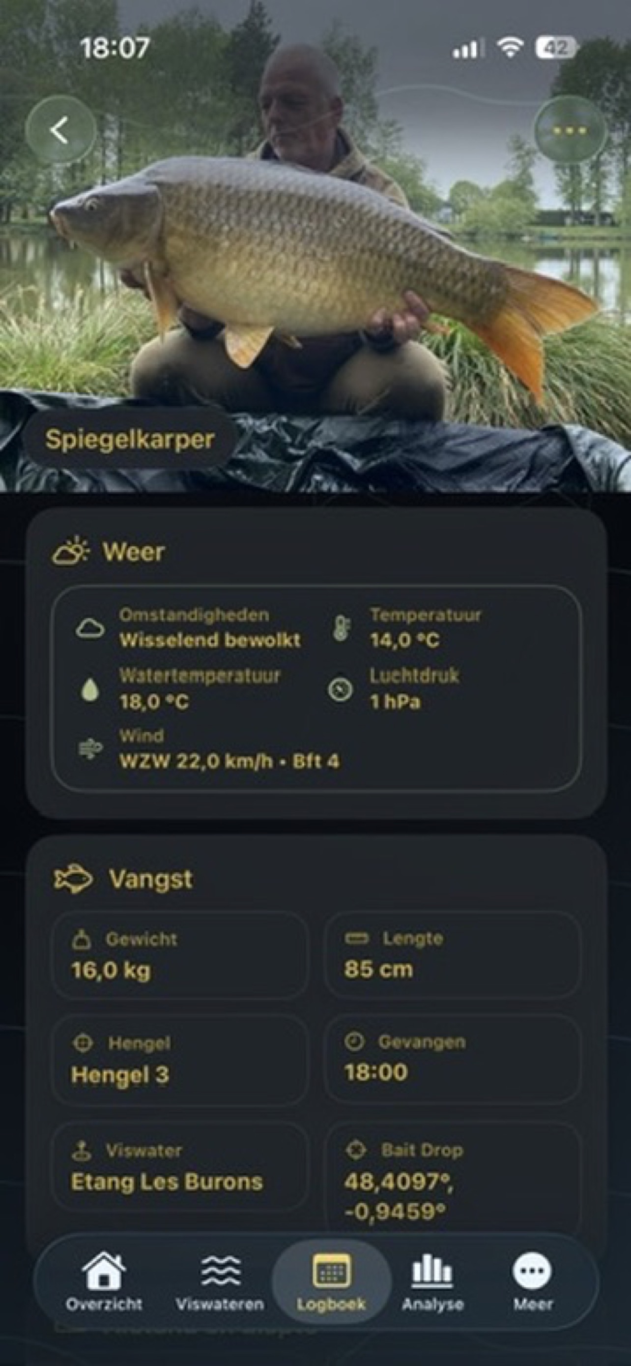
Vangsten
Registreer soort, gewicht, tijdstip, locatie, hengel, foto’s en notities zonder overbodige ruis.
Aas, rigs en flavour
Bewaar boilies, partikels, pop-ups, wafters, flavour, rigtype en details die je later wilt vergelijken.
Weer en omstandigheden
Gebruik wind, luchtdruk, temperatuur, vochtigheid, bewolking, watertemperatuur en tijdvensters als context.
Diepte en bodem
Combineer diepte, bodemtype en eigen fishfinder- of Deeper-data met vangsten en stekken.
Analyse per water
Zie patronen per geselecteerd water, met voorzichtige conclusies wanneer er nog weinig data is.
Support en handleiding
Vind hulp via Q&A, uitgebreide userguide en een supportformulier dat je vraag per e-mail verstuurt.
In de app
Dezelfde premium donkere stijl, van website tot iPhone.
De landingpage gebruikt dezelfde diepe achtergronden, warme goudaccenten, rustige kaarten en afgeronde surfaces als CarpAtlas zelf.
Van download naar gewoonte
De eerste vijf minuten moeten vanzelf gaan.
Een app verkoopt pas echt goed als mensen hem blijven gebruiken. Daarom stuurt CarpAtlas op een eenvoudige start: water, stek, sessie, vangst, inzicht.
Voeg één viswater toe
Begin klein. Kies het water waar je nu het meest vist en geef stekken duidelijke namen.
Log je eerste sessie
Leg datum, tijd, stek, hengels, aasplek en omstandigheden vast zonder je sessie te verstoren.
Registreer elke vangst
Koppel vangst, aas, rig, foto, hengel en locatie aan de juiste sessie.
Lees je patroon terug
Gebruik kaart en analyse om te zien welke keuzes vaker resultaat geven op dat water.
Made for carp anglers
Built by a carp angler, for carp anglers.
CarpAtlas was not designed from a spreadsheet, but from real sessions on the bank. The app follows how carp anglers actually work: learning waters, remembering spots, recording sessions, understanding catches and spotting patterns.
Practical on the bank
No unnecessary input for the sake of input. Only data that helps later with decisions, comparison and analysis.
Built around real sessions
Trips, movements, rods, baiting spots, catches and weather context match how a carp session really unfolds.
For anglers who want to learn
CarpAtlas is for anglers who want to understand their waters better and return a little smarter every session.
What you do with CarpAtlas
From separate sessions to a complete picture of your water.
The app helps you record more than catches. It helps you understand under which conditions they happened.
Build waters and spots
Create a base per water with reference points, depth, notes, photos and relevant zones.
Compare full sessions
Log date, start and end time, rods, fishing spots, baiting areas, weather and movements.
Make catch data useful
Record weight, species, rod, bait, rig, location and time. Consistent input makes filtering and analysis stronger.
Keep context
Wind, pressure, temperature, humidity and moon phase gain value when linked to water, spot and catch.
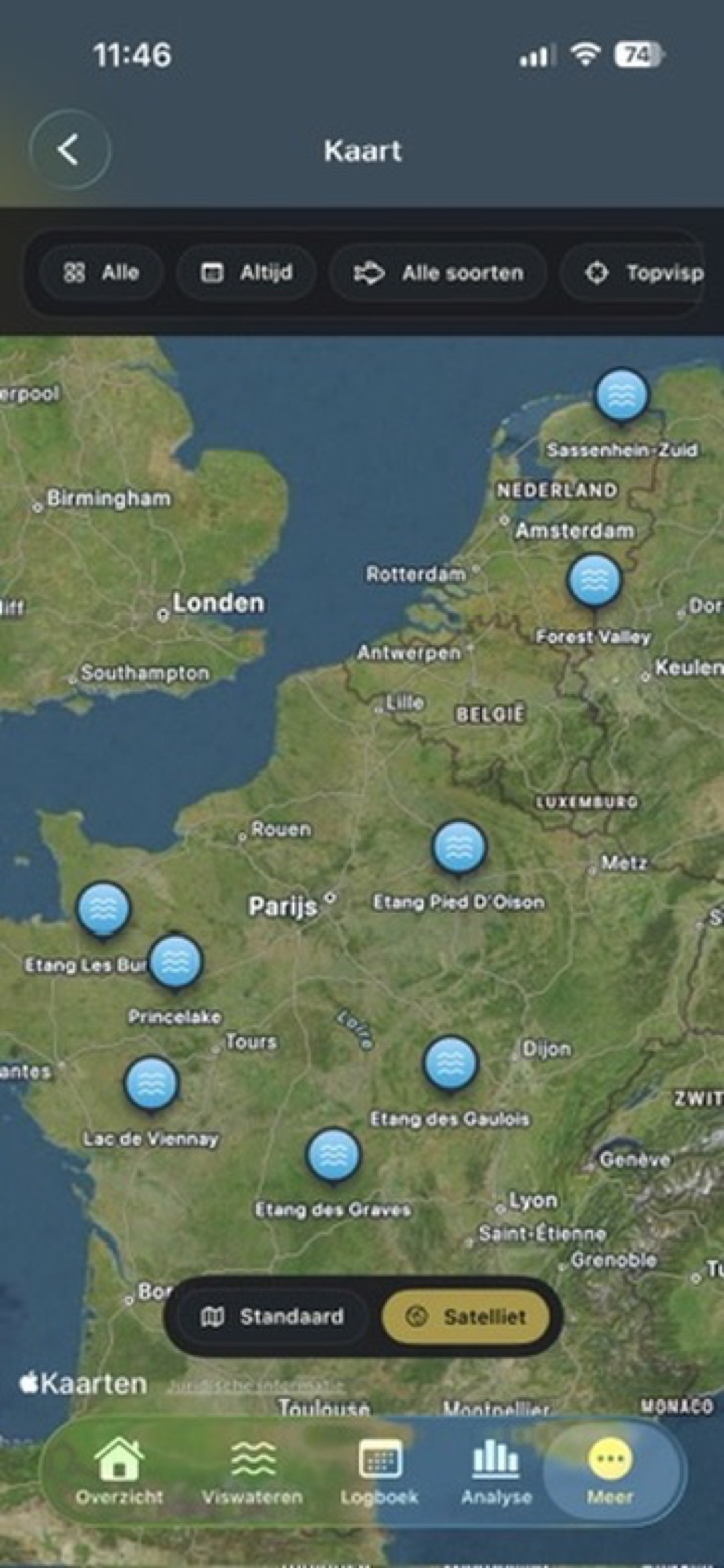
Use the map as memory
Review waters, fishing spots, baiting areas, catch locations and movements visually on the map.
Discover patterns
See which zones, conditions, depths, bait choices and times are more interesting per water.
From session to insight
Four steps to better decisions on the same water.
CarpAtlas is not meant to be an archive. It helps you return a little smarter every session.
Set up your water
Add your water with spots, reference points, depth, notes and photos.
Start your session
Link date, time, rods, fishing spots, baiting areas and weather to the right water.
Record catches and movements
Save exactly where, when and with what you caught — also when you move within one session.
Read map and analysis
See which zones, conditions and choices produce more often on map and in analysis.
Fishfinder & Deeper
Use your own depth data as an extra map layer.
CarpAtlas does not include universal depth maps. If you have your own fishfinder or Deeper data, you can use it to strengthen your water map.
Import it yourself
The user imports their own fishfinder or Deeper data, so it is clear where the bathymetry comes from.
Depth lines as a tool
After import, depth information helps reveal drop-offs, plateaus, channels, shallows and interesting zones.
Combine with sessions
The real value appears when depths are combined with spots, catches, wind, pressure and bait choices.
No magic, better structure
The app does not replace watercraft. It organizes your observations and measured data so you can compare them better.
Why accurate input matters
Analysis improves as your logbook gets cleaner.
A few required fields may feel strict, but they make sure sessions, catches and weather are linked correctly later.
✓ Use consistent names for waters and spots.
✓ Enter weight, rod, time and location as accurately as possible.
✓ Use movements when you change spot or baiting area within one session.
✓ Use weather autofill when available.
✓ Take filters and analysis seriously once you have logged multiple sessions on the same water.
Try fairly. Pay once.
No subscription. Just own CarpAtlas.
CarpAtlas uses a simple free trial limit. You can use all functionality for free with 2 waters, 4 sessions and 8 catches. Want to continue after that? Buy the app for a fixed one-time price.
Gratis starten
2 wateren · 4 sessies · 8 vangsten
Alle functionaliteit is inbegrepen tijdens je proefgebruik.
Daarna
€12.99
one-time purchase · geen abonnement
Try for free
Use all functionality up to 2 waters, 4 sessions and 8 catches. Not a stripped demo, but a real way to experience the app.
No subscription
No monthly costs, no yearly renewal and no hidden paywall for the core functionality.
Full use after purchase
After the €12.99 purchase, you can keep using CarpAtlas without a subscription model.
Privacy first
Your fishing data stays yours.
Your spots, waters, catches, sessions, notes and analysis are not shared with other users, advertisers or external parties. The information stays inside the app with the user.
✓ No shared spot data.
✓ No sale of user data.
✓ No public catch or session data.
✓ You decide what you record and keep.
✓ Designed with respect for personal spots and sensitive fishing information.
Support & userguide
Hulp die net zo rustig werkt als de app.
De supportpagina bevat een uitgebreide handleiding, Q&A en een contactformulier met e-mailverzending naar CarpAtlas.
Uitgebreide userguide
Stap voor stap: eerste start, wateren en stekken, sessies, trips, vangsten, weer, kaartlagen, analyse, privacy en aankoop.
1. First setup
2. Waters and spots
3. Sessions and trips
Lees de handleiding →
Q&A en persoonlijk contact
Antwoorden over starten, privacy, proeflimieten, eenmalige aankoop, analyse, kaartlagen en fishfinder/Deeper-import.
Getting started
Waters, spots and map layers
Stuur een supportvraag →
CarpAtlas
Who is CarpAtlas for?
For carp anglers who return to the same waters, want to record sessions more seriously and want to learn from conditions instead of only storing photos.